The village of Bethany could, once upon a time, be found along the Southern Pacific Railroad’s Martinez-to-Tracy extension, just a few miles outside the latter city’s limits.
These days, few signs remain of Bethany: an old farm road that ends near the tracks is perhaps the most significant remnant. (A reservoir in the nearby Livermore Hills is named for the town, but is several miles distant.)
The Central Pacific Railroad built a depot at Bethany around 1878 along the extension, which was constructed as the San Pablo & Tulare Railroad; in the early Twentieth Century, this section of tracks appeared on USGS maps – including the one below from 1914 – as the Southern Pacific’s “San Francisco and New Orleans Line.”
Today, it is known to railheads as the “Mococo Line.” It was the construction of this extension that led directly to the birth of Tracy at the end of the 1870s.
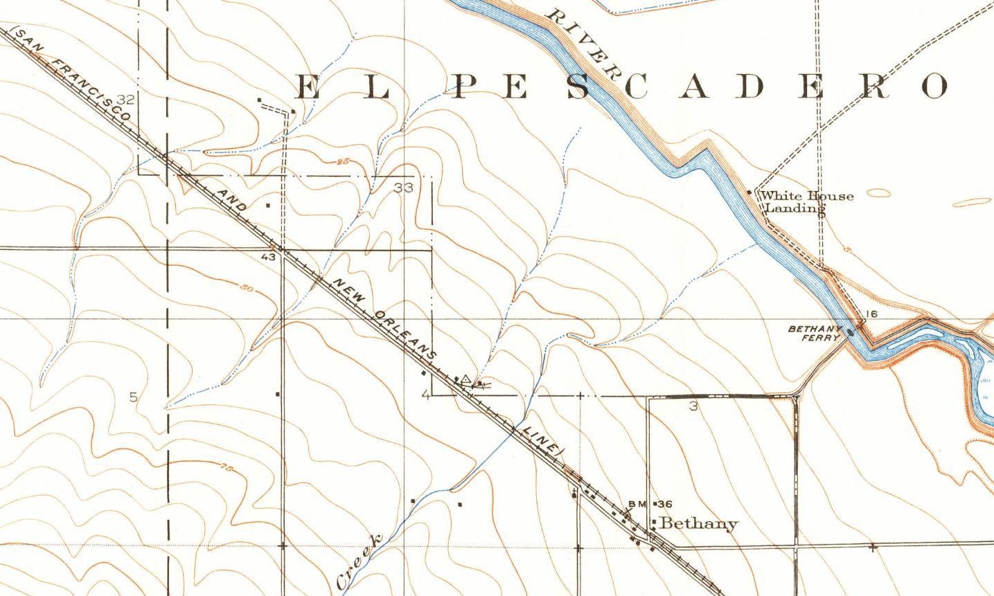
Bethany on a 1914 USGS map, with Old River meandering at right.
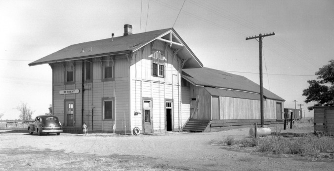
Designated in the SP’s standard plans as a “Two-Story Combination Depot No. 1,” the structure at Bethany was one of fifteen in this style built by the railroad.
Of those fifteen, four were constructed along the Mococo in addition to Bethany: at Antioch, Avon, Brentwood and Martinez. (The Antioch and Avon depots were replaced around the turn of the 20th century with other structures; the Martinez depot was reconfigured into a single-story building in 1942.)
The term “combination” in the plan referred to the dual purposes of the building: it served as both a depot and residence (on the second story, where the station agent and his family lived).
The Southern Pacific’s Time Table No. 239 for the Martinez Subdivision, effective March 26, 1944, showed six passenger trains (three northbound, three southbound) and three freight trains making daily stops at Bethany, including the Owl (trains 25 and 26, carrying overnight riders between San Francisco and Los Angeles via the Los Banos sub) and the San Joaquin (trains 51 and 52, carrying daytime riders between San Francisco and Los Angeles via the Merced sub).
As late as October 1955, the SP’s Timetable No. 262 (excerpted below) showed the Owl as Train 58 departing daily – or, more accurately, nightly – from Bethany at 11:14 PM, with the San Joaquin Daylight (Train 52) leaving the depot at 9:35 AM each morning on the way to Tracy.

Bethany, between Herdlyn and Janney on the Martinez Sub, shown on the SP’s Timetable No. 262 in 1955.
In the rustic Bob Morris photo of the Bethany station at the top of the page, a child – perhaps the offspring of the resident station agent – plays in the depot’s dusty parking lot. Beyond the covered freight dock, which is open on the far (track) side, a lone boxcar waits.
The Bethany depot was closed in 1959, perhaps a year or so after Mr. Morris captured it on film for posterity, and it was subsequently torn down.
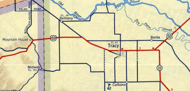
ABOVE: Detail from a 1951 Shell Oil road map of Tracy and environs, showing the location of Bethany, along the old Byron Highway at the junction with Bethany Road (both unmarked on this map).
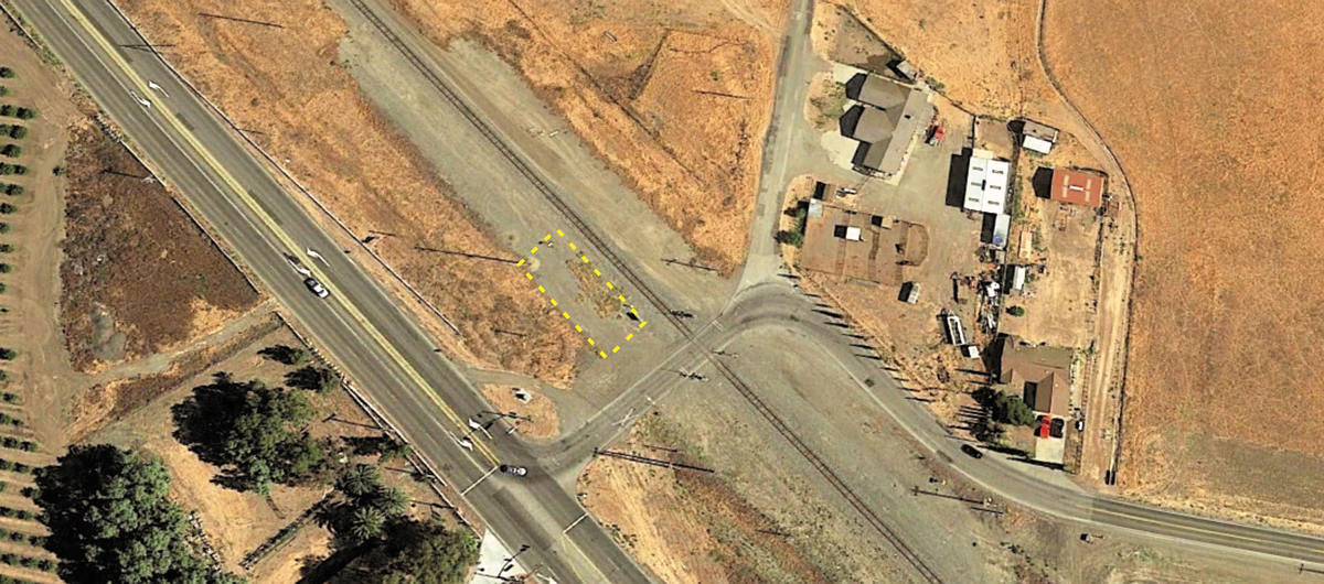
ABOVE: A Google Earth aerial view of the Bethany area as it appeared in 2018. The yellow rectangle designates the approximate location of the Southern Pacific depot.
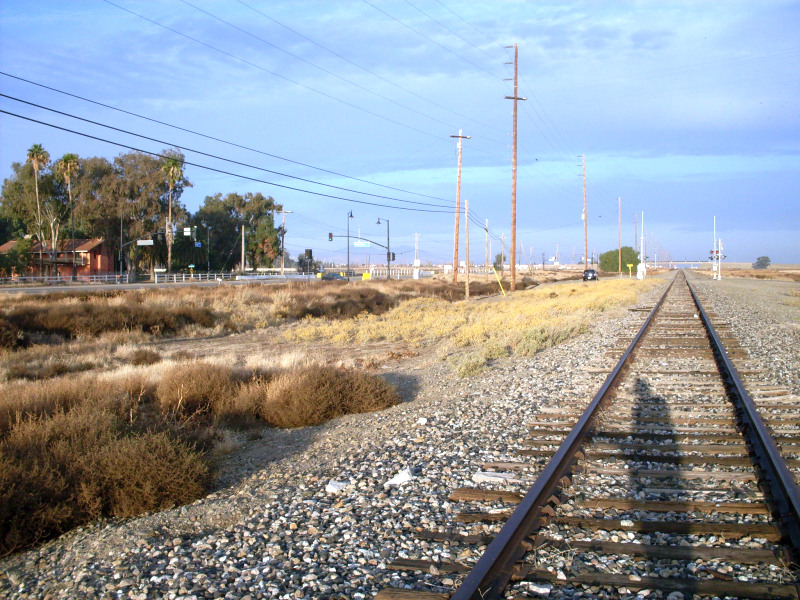
ABOVE: Looking north on the Union Pacific tracks toward Henderson Road (ahead at the grade crossing), with Byron Highway on the left, running parallel to the tracks. The Southern Pacific’s Bethany depot would have stood in the brush to the left, between the tracks and the highway. A siding ran between the mainline and the freight depot.
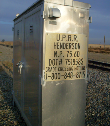
The Union Pacific signal box at Mile Post 75.60 on the Mococo Line, located at Henderson Road off the Byron Highway, adjacent to the estimated location of the old Bethany depot. On the Southern Pacific, the Bethany depot was located at Mile Post 75.7, six-and-a-half miles distant from Tracy.

Bethany Road street sign at the intersection with Henderson Road, adjacent to the tracks at Bethany. Turning off Byron Highway, Henderson Road crosses the train tracks then branches left, while Bethany Road branches right. Eastbound, as noted by the sign in the left distance, Henderson is “not a through road.”
REFERENCE: “Southern Pacific Lines Standard-Design Depots” by Henry E. Bender Jr. (Signature Press, 2013); “Southern Pacific Depots In California, Volume 1” by Stephen M. Hayes (Hayes Publishing, 2010).
Special thanks to Robert Morris for his generous permission to reprint his circa 1958 photograph of the Bethany depot.
Text and contemporary photographs (November 2013) by David Jackson.


In the photo looking North, according to the Google earth picture and the other info you’ve provided, the Bethany Depot would be on the other side of the Henderson Rd crossing, on the left, between the tracks and Byron Hwy. But, I know exactly where you’re talking about, I parked there to get pictures of the 2 WP boxcars stored by UP in the line of boxcars and hopper cars that stretch from there to the Central Avenue overpass along Byron Hwy.
You are correct, Joshua. I was guessing at the location based on the Bob Morris photo and my own “walk around” visit – I couldn’t find an aerial photo of it or a map that flagged “depot,” so I guessed, figuring I had a 50/50 shot.
As I tell everyone who knows me: if I bet one way, you should bet the other way.
DJ